Friday, January 31, 2014

Popina Laka - Mozgovitsa - Tevno Ezero (Bulgaria)

We left from Sofia Friday evening after work and arrived at Popina Laka at around 11. We slept at a guest house "Goran". The same evening Dontcho (the hut manager of Spano Pole) and Ivan (the hut manager of Tevno Ezero) appeared. They warned us not to go along the river Mozgovishka, but to follow the snowy trail made by the sleds through Begovitsa.
 The next morning we left early. At the beginning we walked without  snowshoes, but little by little we started to sink in the snow - there were no trails, the snow was melting and the path was not visible.
Having crossed the path from Begovitsa to Spano Pole it was easier to walk but not much.
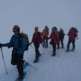
Going out of the forest we felt more comfortable. The snow was clumped and we went on easily.
With every step on, amazing panoramas showed up.
We heard and saw an avalanche falling under the furrow of Kamenishka Kukla but I didn't have time to take out my camera and make a clip.
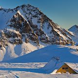
We arrived at Tevno Ezero half an hour before dark.
Just time for a beer and taking pictures of the sunset from the nearest edge.
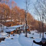
The next day we went down through Begovishki Preval and Begovitsa hut.
At Dakov bridge we met a group from Sandanski.
In general nice mountain, nice weather, nice people, everything was perfect :-).

Photos


GPS track

Kaimakchalan (Nidze)

We left on Friday evening and around 1.30 at night we pitched our tents near Rupite.
The next day we entered Greece. The first thing to visit were the waterfalls in Edessa (that was not planned but it was worth it):
We climbed Kaimakchalan from the ski center bellow. It wasn't difficult. The denivelation was only 500 meters. On the top there was a Sеrbian chapel in memory of those who died in battle during the first world war.
The evening we slept down the road in a fruit garden.
On our way back to Bulgaria we passed through Macedonia, where the custom officers were not very nice with us, but however their traditional meat "kebaptche" was not bag at all :).
Photos


GPS track


Assara - Moniak - Ustra - Perperikon (Bulgaria)

This was mainly a car trip for two days. About most of the places I knew from a meeting with friends where I took notes and strictly followed them.
We first arrived at Assara - a place with interesting clustered rocks with a lot of rock niches on.
Here is the biggest one with the niches.
Then we moved to the fortress Moniak. It is situated on a very panoramic place, but there is not much left of it.
But the next day we were pleasantly surprised by the castle Ustra.
Unfortunately the Ustra hut situated in the foothills seemed to be abandoned. Our trip ended with Perperikon - an ancient Thracian city.


Photos:


GPS track

Wednesday, January 22, 2014

Second meeting of "Ima Bira" at Rai hut (Bulgaria)

What made impression during the trip was that the snow has melted on the southern hills of the mountain.
We gathered a large group at around moon at Panitsite and climbed up to the hut.
We were carrying snowshoes on our backpacks without using them at all. We just put them for a little while because of the icy slopes in the forest.
On Saturday there was a strong wind. In the evening it became stronger and was banging the windows all night. The next morning it still blew strongly, so we decided to go back safely to the cars and visit a restaurant somewhere nearby.


Photos
GPS track

Trite Tchuki and Kopren in winter (Bulgaria)

The initial plan that we made with Slaveiko was to go to peak Midjur and sleep at hut Gorski Rai. The last moment it turned out that the hut is closed due to the snow and we had to change the plan. Georgi suggested Kopren, Toni added Trite Tchuki and warned us that it's not safe to climb them in winter.
So the Saturday we traveled, then we visited a restaurant and later on we spent some time in searching a cave above Beli Mel which we didn't find anyway.
Sunday morning we got up early and took off. The weather was perfect. The snow was good for walking with snowshoes.  
At the beginning we walked northwest on the road to Tchiprovtsi.
Then we diverted west and aimed a safe rib on the ridge.

As we got on the top of the ridge we carried on to the most spectacular part of the route- the edges of Trite Tchuki.
And here is the sharpest one.
We realized that descending the icy and steep hill was much harder than passing the edges on the top.


A map of the route:


The rest of the photos

GPS track

Friday, January 17, 2014

City Karlovo- hut Ravnets- shelter Botev - peak Kostenurkite (Bulgaria)

We met at Karlovo. Svilen came from Varna and the rest of us from Sofia. We first reached the hut Ravnets and went on up. Most of time we were walking in fog and of course in dark.
Around the area Kochmara the fog has gone and we were lucky to be able to take some pictures.
The sunset reached us after having crossed the summer path from hut Levski and hut Rai.
Two of us, Niksi and Toni decided to save some distance and took the summer path. But Svilen smiled and followed the winter marking to Jaltets. The idea of hacking the ridge especially in winter and in the dark and fog ended quickly and we soon followed Swilen. As we arrived at the shelter Botev we found a group of young people, but the hut manager wasn't there. Arrangements were next morning to get up at 6.00 a.m. and departure at 7.00 a.m.for the peak Kupena.
On the next morning the alarm rang at 6 о'clock. But nobody wanted to be the first to get up so early and so we slept a little bit more. But still we managed to take off at 7.30 (without Eli and Desi who stayed to go back the same way we came.)
Around Jaltets the sun came out of the clouds and escorted us.
We hacked the peak Kostenurkata.
We carried on quite scattered.
Somewhere at the last descents I decided to give up. I couldn't imagine that I will pass with my backpack on this narrow edge covered with snow and ice and cliffs on both sides. Svilen also decided to come with me. We went down on the way back to Jaltets and then to Ravnets where we caught up Eli and Desi.
Meanwhile the rest of the group succeeded to pass the Krastsite and arrived at Karlovo late in the evening.

All photos

GPS track

Tuesday, January 14, 2014

Demyanitsa hut - Todorka peak (Bulgaria)

After three consecutive years of meeting New Year at Zavrachitsa hut, came the idea of going in Pirin mountain this time. It was snowing on the morning of 31 of  December. The journey was quite snowy. Driving up to Bansko was really dread. There was an endless column of cars, some of them stalling, others swaying and those with jeeps were poking to anticipate...


On the first day of the New Year of course we didn't leave early in the morning. Although the snow was deep and fresh we reached easily Vasilashki Lakes. From now on started the grief, especially for the front one who was braking out the snow. We stopped for a rest at the first lake and there we met Valio, Tsveti and three others (Denka, Ves and Assen) who were not wearing snowshoes. It was not easy at all for them to go sinking to the waist in the snow.
We went on.

However as Janko traditionally was not wearing gaiters, his feet got wet and frozen, so he had to return with Petia. That was no good for me as he was a chance to replace me in the front. A little before Todorka my legs started to get heavy and I was thinking of giving up, when fortunately Tsveti run forward making a path in the snow. But in a while it turned out that someone more powerful and long-legged is needed , so will I will not went again in front.

The whole group got together on the peak, stayed there for a while, made some pictures and went back.


All photos
GPS трак

Lakatishka Rila (Bulgaria)

After having tried unsuccessfully to reach the Ivan Vazov hut the day before, because of the bad weather, we took off on Sunday again. This time, as it was expected, the weather was perfect, the sun was shining bright. Still it was not suitable for taking pictures. The district of Maliovitsa was covered with clouds.
After a while the clouds were gone, but still the visibility was not so good.
All photos
GPS track

A lot of snow and peak Popovi Ushi (Bulgaria)

As Saturday was а working day, we left on Sunday morning and were welcomed with a wonderful sunrise on the road.

The highway to Pernik was one band under the snow and the other with tracks in the ice. Around Breznik and Tran the roads were terrible - no snowblower has passed recently.

The idea was to reach the peak Bilo in the mountain Karvav Kamak. The road after Tran became even more terrible, but we somehow managed to arrive at the village Dolna Melna.  From now the road to Shipkovotsa was covered with snow and impassable. It wasn't a good idea to leave the car here as we had to walk 7 km to the village. It became obvious that we won't be able to reach Bilo this day. The car started to crawl up again in the snow and passing round a parked car it plowed in the drift and strapped. I pulled a shovel and started to dig. But there was ice under the snow. It took time and efforts but we were on the road again. It was getting late and we were convinced that it's meaningless to go to Bilo this day. So we went back to Dolna Melna and wondered around for a while. 

Meanwhile we decided to go back to Zemen.

And so during the wandering that day we reached the peak Popovi Ushi. But the worst was that after all the troubles, we arrived at Zemen to find out that no restaurant was working this day.
All photos
GPS трак